PANEL 1: Munidorf – The Fake Village
A Hidden Ammunition Depot
During the German occupation of Denmark from 1940 to 1945, the Germans developed Aalborg Airport beyond recognition for military use. Shortly after the invasion on April 9, 1940, the first steps were taken to establish a camouflaged ammunition depot, outside the airport area out of fear of British air raids. The Germans chose a field located between Birkelse and Aabybro. The plan was to build a fake village to camouflage the depot, so that it wouldn’t be bombed by the British.
Disguised as a Village
A field belonging to Birkelse Manor was taken for this purpose, and by the end of May 1940, craftsmen began constructing a fake village, which the Germans named Munidorf (Muni = ammunition and Dorf = village, translated from German).
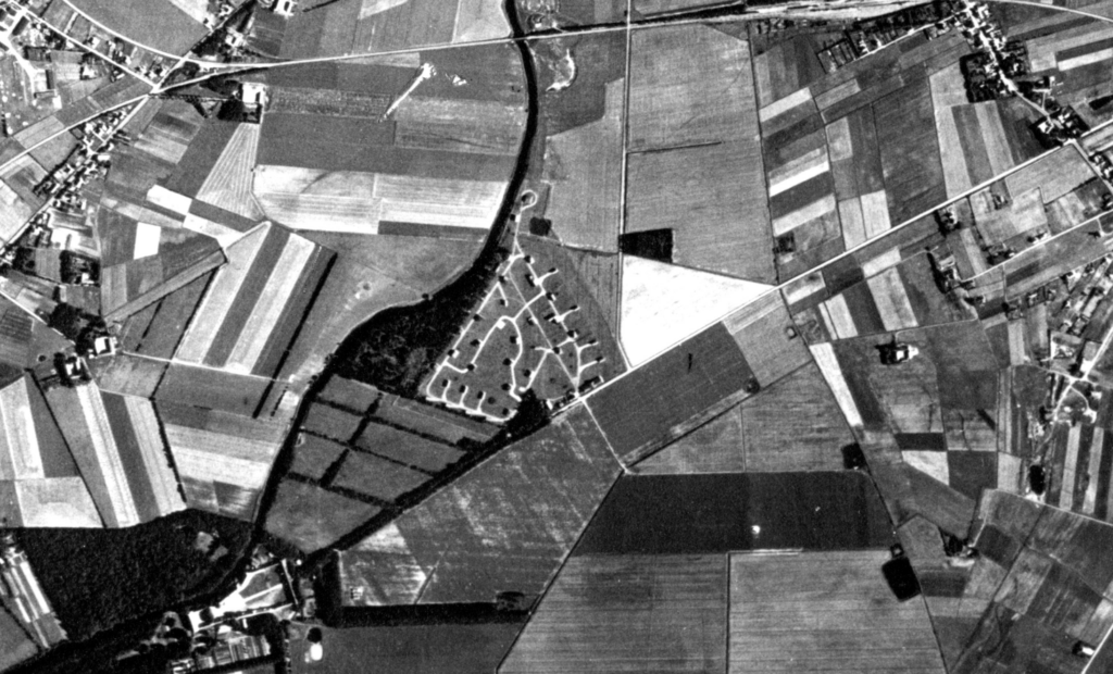
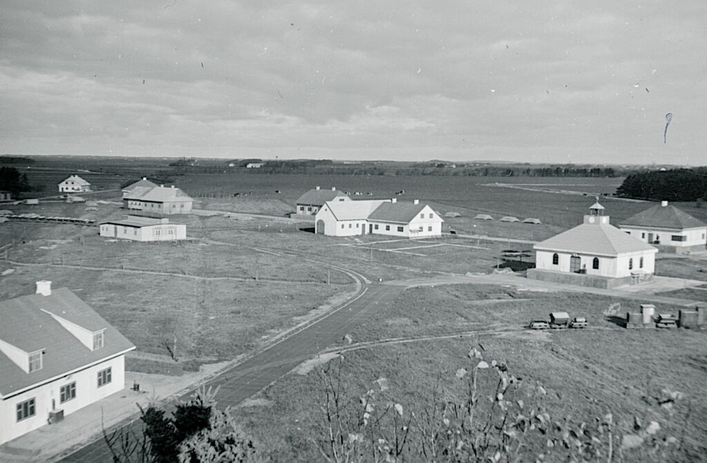
Image 1.1 – In the middle of the image the fake village “Munidorf” is visible. At the bottom left is Birkelse Manor, owner of the area, and at the top center is the railway bridge, right next to where you are standing now. On the far right, you can see part of Aabybro. The fake village was located on the field right in front of you.
Photo: Royal Air Force, aerial photo from 1945.
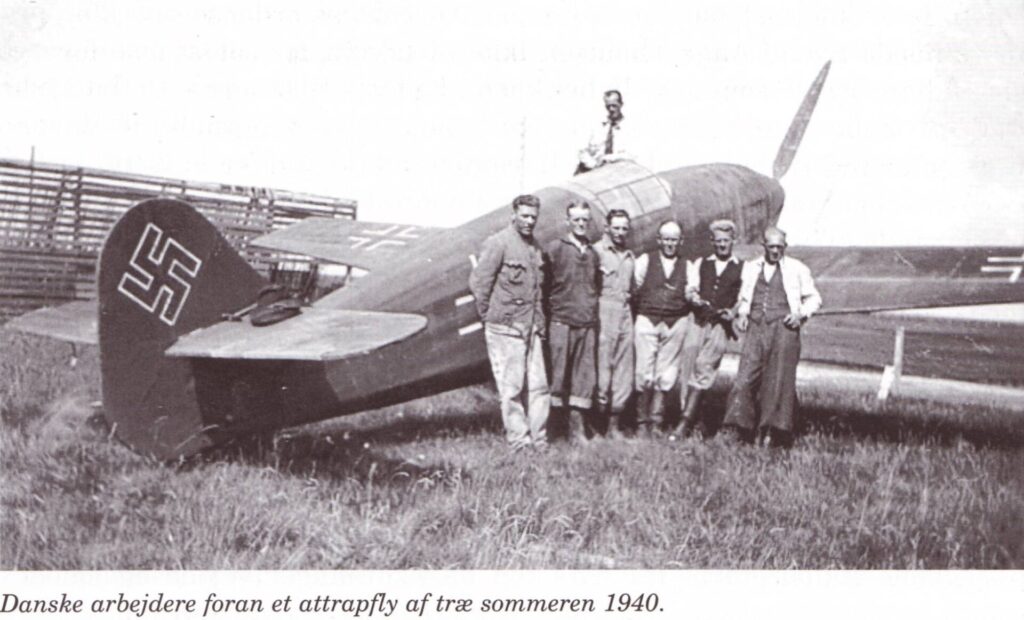
Image 1.2 – A group of workers are making formwork for the bunker in Munidorf. The walls and roof were “only” 40 cm thick: The bunker was most likely used for storing fuses for ammunition and aircraft bombs.
Photo: Historical Association for Aaby Parish.
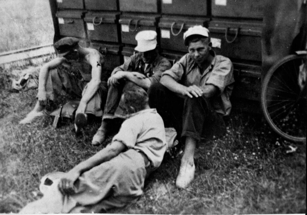
Image 1.3 – The work was carried out by the Danish construction company Fuchs and Gröne, which employed up to 100 Danish workers in the first year of building the village. Here, some of the workers are seen during a break.
Photo: Historical Association for Aaby Parish.
PANEL 2: Direct Connection to the Airport
A Narrow-Gauge Railway
A narrow-gauge railway was laid from the airport to Aabybro Station, passing through Munidorf. From Aabybro Station, a siding ran westward, parallel to the railway. The siding looped around the bunker and continued under the railway bridge along the stream. The narrow-gauge railway ran into the fake village, where it branched, so that ammunition and bombs could be loaded from the various buildings. From Munidorf, the railway continued about 10 km southeast to the airfield, where the ammunition could be unloaded.
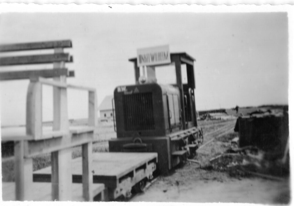
Locomotives David, Goliath, and Uncle Wilhelm
To transport the ammunition there were three small diesel locomotives, manufactured at Pedershaab Machine Factory in Brønderslev. Near Skeelslund Forest about halfway between Munidorf and the airport, there was a maintenance pit for the locomotives.
Image 2.1 – The narrow-gauge railway looped around the very bunker you are standing on and then passed under the railway bridge. Back then, the stream was narrower, so today it may be hard to imagine railway tracks running under the bridge.
Photo: Historical Association for Aaby Parish.
Image 2.2 – The area where the fake village was built is marked in green. The red line roughly shows the route of the narrow-gauge railway from Aabybro Station, past the bunker at the railway bridge, and southeast to Aalborg Airport.
Source: Historical Association for Aaby Parish.
Image 2.3 – One of the small diesel locomotives that transported bombs from Munidorf to the airport. By the end of the occupation, there were three locomotives on site, nicknamed David, Goliath, and Uncle Wilhelm.
Photo: Unknown.
PANEL 3: Camouflaged as a Village
An Ordinary Danish Village?
At first glance, Munidorf looked like a typical Danish village with farmhouses, a school, a dairy, and a church. But the entire village was just a facade with painted doors and windows, a fake clock on the church tower and fake hollyhocks on the house fronts. About 40 houses and one bunker were built. In the houses, the Germans stored ammunition, aircraft bombs, fuses, hand grenades, and more. The roads between the houses were covered with painted wooden planks of the highest quality from Pomerania in northern Germany. It is not known exactly how much material was stored in the secret depot, but one source says it was up to 48,000 tons of ammunition.
The British Knew About Munidorf
The British knew about the town’s location in 1944, and knew that it was actually an ammunition depot, but Munidorf was never bombed. Either the pilots could not recognize the place during flyovers, or they deemed it too risky to bomb an ammunition depot so close to civilian dwellings.
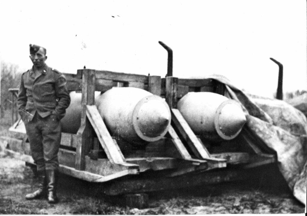
Image 3.1 – A German Luftwaffe soldier poses in front of a couple of large bombs, of the SC1800 type, which weighed 1800 kg. The rings on the bombs’ heads are so-called “Kopfringe,” which were meant to ensure that the bombs did not dig too deep into the target before exploding. The large bombs lay on sleds in the open air until more barracks were built for storage.
Photo: Historical Association for Aaby Parish.
Image 3.2 – A map from 1944 found in an English archive. Note the upper left corner: “Birkelse Ammunition dumps for Aalborg West.” The map clearly shows that British intelligence sources knew Munidorf’s location.
Source: Jørn Junker.
PANEL 4: Photographs of Munidorf
4.1 – Photo: Historical Association for Aaby Parish.
4.2 – Photo: Ole Rønnest.
4.3 – Photo: National Archives.
4.4 – Photo: Historical Association for Aaby Parish.
4.5 – Photo: Historical Association for Aaby Parish.
4.6 – Photo: Ole Rønnest.
4.7 – Source: Aalborg Stiftstidende, January 20, 1946, The Historical Newspaper Archive Nordjyske.
4.8 – Photo: Freedom Museum’s Photo Archive.
PANEL 5: A Worker’s Memories
He Built Munidorf
The fake village was built with Danish labor. One of the workers was the 22-year-old carpenter Jens Chr. Michaelsen, who later wrote down his memories of Munidorf.
(Quote): “All the barracks were camouflaged so that from the air they could appear as a small town. On almost all the flat roofs, new rafters with a higher pitch were installed. Battens were nailed on, and then roofing felt in various colors was laid, so the buildings appeared with, for example, green, red, or gray roofs. One was clad with reed mesh to resemble a thatched roof. The church was equipped with a small bell tower. The ‘dairy’ had a special roof with ventilation caps. The exterior walls were painted with various forms of doors and windows, some buildings were even painted as half-timbered. It actually looked quite nice from a distance.”
Nazis and Ordinary Germans
(Quote): “The German guard units stationed at the depot were regularly rotated. The young ones were generally eager Nazis and not approachable. Another unit was there for quite a long time: They were, for the most part, somewhat older, even so old that they had participated in World War I. They were more prudent, and I don’t think any of them were real Nazis. One of them said to me: ‘I didn’t ask to come up here. Don’t you think I’d rather be home with my wife and children?'”
Image 5.1 – Jens Christian Michaelsen (April 28, 1918 – May 31, 1991) was one of the Danish workers who helped build the fake village in 1940-41. His memories of the time are the most important testimony we have about Munidorf.
Photo: Karin Funch.
Image 5.2 – Danish workers enjoying lunch in the shade of ammunition boxes. Initially, there was no foreman to oversee the construction, which meant many breaks throughout the day. Later, a foreman arrived, and there was more supervision.
Photo: Historical Association for Aaby Parish.
QR Code: Listen to Jens Chr. Michaelsen’s story, narrated by Per Christiansen (in Danish).
PANEL 6: The Construction Company Fuchs and Gröne
From Haderslev to Aabybro
The construction of Munidorf was organized from the German construction office in Aalborg, also known as Bauleitung Aalborg. Bauleitung Aalborg hired the newly established construction firm Fuchs and Gröne to build Munidorf. Initially, the contract stated that 18 barracks should be built, with more added later. Owners Friedrich Fuchs and Ludvig Heinrich Gröne arrived in Aabybro on May 28, 1940, where they immediately began work. They brought a lot of equipment and some workers, but more labor was needed, which was hired locally. Within a month, they had 100 men working.
Convicted as German Collaborators
Munidorf was largely completed in the summer of 1941, but Fuchs and Gröne’s work on maintenance and remodeling continued throughout the war, while also undertaking a wide range of other constructions for the Germans. Fuchs and Gröne both had backgrounds in the German minority in Haderslev, which was likely a contributing factor to their being sentenced to prison terms and large fines during the Retsopgør, the legal aftermath at the end of the occupation. Over the five years of occupation, Fuchs and Gröne had a turnover of almost 34 million kroner.
Image 6.1 – Friedrich Fuchs was born in Haderslev in 1901. He was originally trained as an architect and ran a small construction company in Haderslev before moving to Aalborg in the spring of 1940.
Photo: National Archives.
Image 6.2 – Ludvig Heinrich Gröne was born in 1874 in Broager, Southern Jutland. Gröne ran a versatile construction business in Avnbøl but was living in Haderslev before moving to North Jutland in the spring of 1940.
Photo: National Archives.
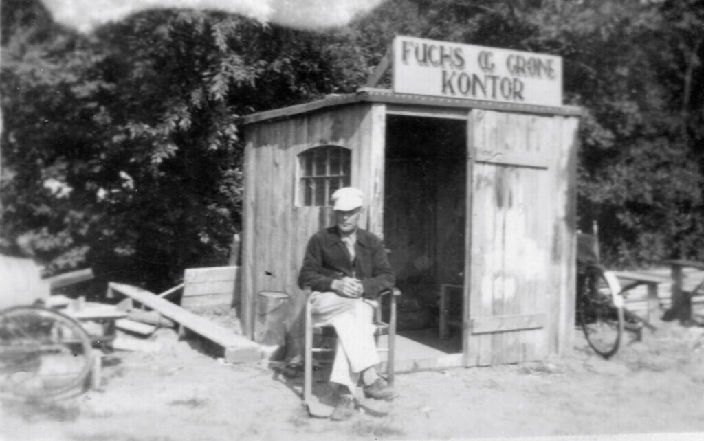
Image 6.3 – An improvised foreman’s hut in Munidorf.
Photo: Søren Flensted.
PANEL 7: Evald, “The Dog Handler”
Convicted as a Traitor
In Munidorf, several Danish employees were hired to perform tasks other than construction. One of these was the laborer Evald, who, during the legal aftermath, was convicted of having worked in Munidorf to promote German interests, beyond what could be considered ordinary civilian wage labor.
35-40 German Soldiers in Munidorf
Evald was employed from December 1944 until the liberation. According to Evald’s own explanation, his job involved feeding, training, and walking the four to five guard dogs in Munidorf, stoking the stove, and cleaning the barrack after the German soldiers. Additionally, he also served as a “holiday replacement” for the six Danish guards who were also employed in Munidorf. These guards were, however, dismissed in mid-March 1945 after being caught playing cards during work hours. After that, the Germans took over the guard duties. According to Evald, Munidorf was manned by 35-40 German soldiers and the six Danish guards.
Bombs to Berlin
From mid-April 1945, Evald’s tasks changed significantly. He was now to help transport bombs and ammunition to the airport, working almost around the clock – for double the hourly wage. Most of the ammunition in Munidorf was probably to be transported south, for use in the defense of Berlin.
Image 7.1 – Evald grew up in Himmerland and was trained as a gardener. During the legal aftermath, Evald was sentenced to one year in prison and lost public trust for five years for his work in Munidorf.
Photo: National Archives.
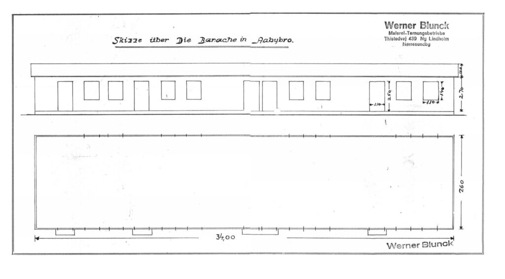
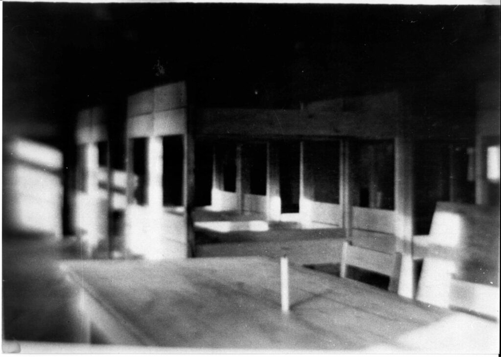
Image 7.2 – There are no pictures of the German personnel barrack in Munidorf, only this sketch. It was here that Evald was supposed to clean and stoke the stove. The barrack was probably located in the forest area “Dyrehaveskov”, the small patch of woods between Munidorf and Ryå.
Photo: A.C. Johansen.
PANEL 8: Munidorf After the Liberation
The Ammunition Depot is Dismantled
In the months after the liberation of Denmark on May 5, 1945, the ammunition depot was slowly dismantled. Bombs and grenades were transported away and detonated by remaining German soldiers under English control. The wooden barracks were dismantled and transported to the airfields Aalborg West and See, where they were to be used for housing the many thousands of German refugees who were in North Jutland.
The Accident
In October 1945, German soldiers were still present in Munidorf, and a violent explosion occurred in one of the wooden houses – presumably the church. A couple of non-commissioned officers had been playing with an anti-tank grenade, which exploded in their hands. The explosion killed the two German soldiers and injured six others. The entire side of the house was blown out and lay 15-20 meters away. Miraculously, the detonation did not cause the large stockpile of hand grenades also stored in the church to explode.
Few Traces Today
Today, there are not many traces of the fake village, but there is still a single concrete bunker in the area, which is now a Christmas tree plantation. The remaining bunker was probably used for storing fuses and detonators for ammunition and bombs.
Image 8.1 – After the war, a refugee camp was set up at the airport.
Photo: Unknown.
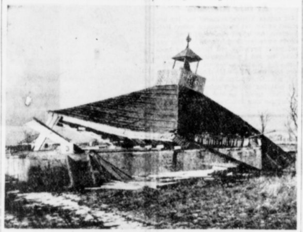
Image 8.2 – The church collapsed after the violent explosion that cost two German non-commissioned officers their lives.
Source: Aalborg Stiftstidende, January 20, 1946, The Historical Newspaper Archive Nordjyske.
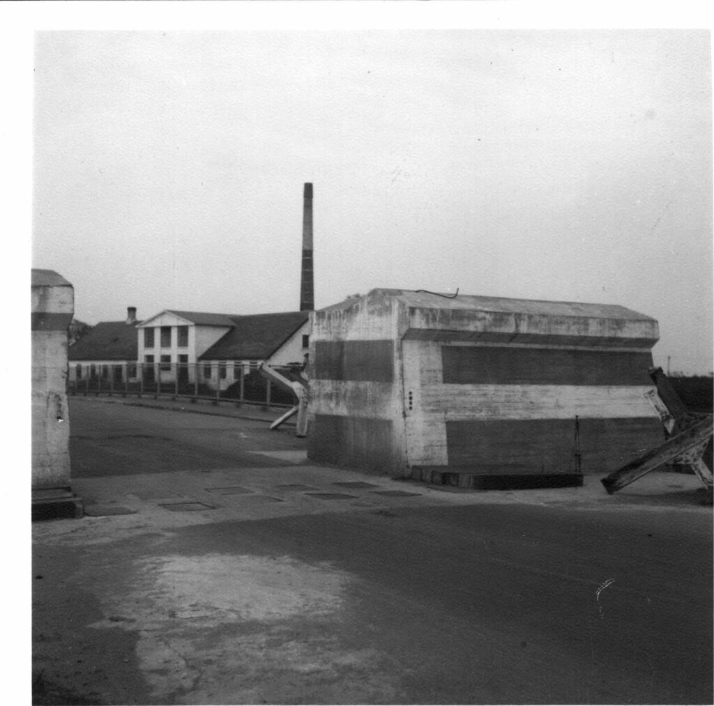
Image 8.3 – The bunker in the picture is the only remaining part of Munidorf. The bunker has relatively thin walls, and fuses for aircraft bombs were likely stored here.
Photo: Peter Mølgaard.
PANEL 1: Aalborg West Airfield
The Important Airport near Aalborg
The Germans’ main goal in the occupation of Denmark was to secure control with the airport near Aalborg, which could act as a transit point between Germany and Norway. When the Germans occupied Denmark on April 9, 1940, they immediately took control of the airport. The airport area was occupied by paratroopers early in the morning, marking the first time in world history that this type of troops was used to occupy foreign territory.
German Ambitions
For the airport to accommodate the large German bombers, extensive development of the airport’s runways and facilities was necessary. The expansion of Fliegerhorst Aalborg West (Aalborg West Airfield) was initiated immediately, and by July, the first of two new concrete runways was ready for use. Anti-aircraft guns were set up, concrete hangars and barracks were built. About 270 houses and farms, including the large estate Rødslet, were leveled to make room for the construction. Up to 16,000 men were working there when construction was at its peak.
Image 1.1 – Aalborg Airport was inaugurated in 1938 with a large air show. About 100,000 people attended. When Denmark was occupied, the small airport was the main target for the Germans, and within a few months, the airport had been massively expanded – it became the largest airport in Northern Europe and was, at times, the largest workplace in Denmark.
Photo: Unknown.
Image 1.2 – This picture was taken around 1945-46. In the foreground, you can see some of the many hangars, in the middle are the runways in an “A” shape, and in the background is Aalborg.
Photo: Unknown.
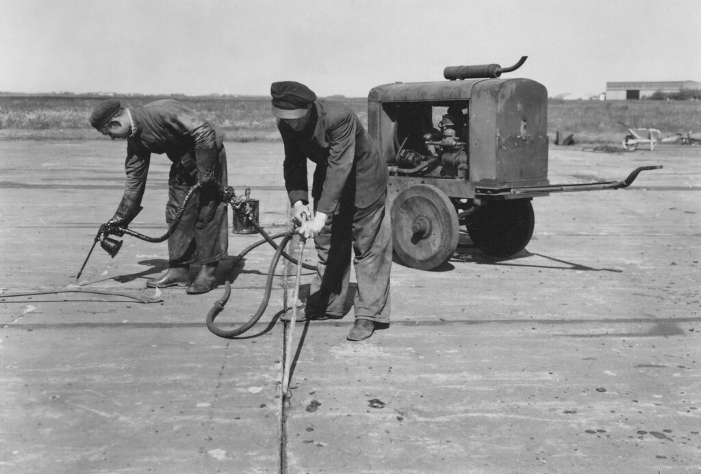
Image 1.3 – Two Danish workers are maintaining one of the new concrete runways at Aalborg Airfield.
Photo: Unknown.
PANEL 2: The Airport under attack
British Focus on Aalborg
After the expansion, Aalborg Airport was among the largest in Europe, making it an obvious bombing target for British flyers. British planes made several attempts to bomb the airport, with varying success, during the spring and summer of 1940.
The Fateful August 13
Especially the attack on August 13, 1940, ended in tragedy for the British. Originally, 12 Blenheim bombers were on their way from England to Aalborg Airfield, but one plane had to turn back due to engine problems before reaching the Danish coast. The remaining 11 planes continued towards Aalborg, but the German air surveillance posts along the west coast observed the planes and immediately notified the airfield.
11 Downed British Bombers
The German anti-aircraft batteries were ready, and fighter planes were also sent up to meet the British bombers. The British managed to drop a few bombs over the airfield, but all 11 bombers were shot down. It was an unequal fight, as the German fighters were more maneuverable and faster than the bombers. One of the planes, Blenheim R3904, crashed two kilometers east of Aabybro. Only the pilot survived, but he was captured by the Germans and transferred to a German POW camp. Two other planes crashed near Kaas, and two in Tranum Klit. This attack on August 13, 1940, is considered the largest air battle over Denmark during the entire occupation.
Image 2.1 – The air battle made the front page of Aalborg Stiftstidende the next day. Two Danish workers at the airport lost their lives, and six were injured during the bombing attack.
Photo: Aalborg Stiftstidende, August 14, 1940, The Historical Newspaper Archive Nordjyske.
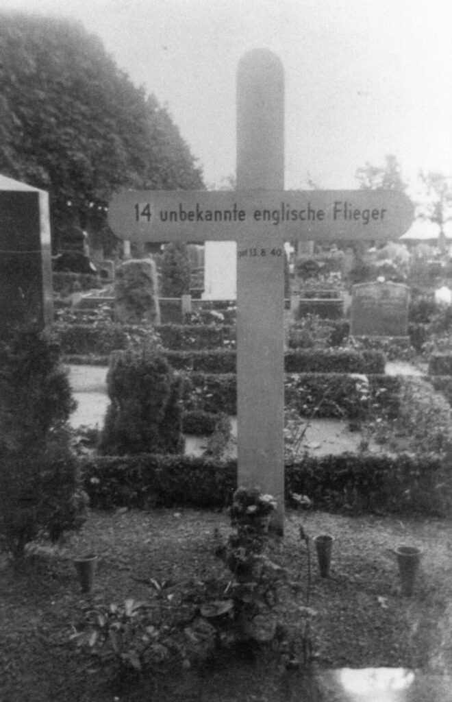
Image 2.2 – The victims of the bombing raid on August 13, 1940, were buried at Vadum Cemetery, where several other British pilots were already buried. The cross reads in German “14 unbekannte englische Flieger”: 14 unknown English pilots.
Photo: Søren Flensted.
PANEL 3: Defense of the Airport
FLAK Positions
The gigantic airport needed a suitable defense system: The Germans knew that Allied planes would attempt attacks. Around the airport, a series of so-called FLAK positions (Flug Abwehr Kanone) – anti-aircraft gun positions – were built. These guns were set up at intervals all around the airport area, from Vadum in the east to Gjøl in the west. The largest FLAK positions had rangefinders, communication facilities, and crew bunkers, so that there could always be gunners on watch.
Searchlights outside Aabybro
To detect incoming enemy planes, there were listening stations scattered around the landscape, and searchlights were set up both along the coast and inland. East of Aabybro, at Torngårdsvej, two searchlights were placed, and the location was not picked at random, as from there, there was a clear view to Aalborg West Airfield. The searchlights were there to help the gun positions around the airfield illuminate the planes so that the soldiers at the FLAK positions could shoot them down.
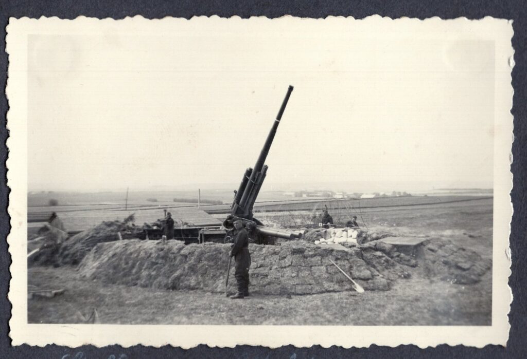
Image 3.1 – One of the heavy FLAK guns. Batteries of this type were placed all around the airport and within the airfield area. This type of gun caused many British casualties in the Aalborg area.
Photo: Søren Flensted.
Image 3.2 – This type of searchlight was placed east of Aabybro. Note that it was both on wheels and had a drawbar so the searchlight could be positioned where needed. The lamps were extremely powerful and could illuminate several kilometers.
Photo: Søren Flensted.
Image 3.3 – A sketch of the large FLAK battery at Gjøl. The battery was located north of Gjøl church, right in the flying path to the airport.
Source: A.C. Johansen.
PANEL 4: Dummy Airfields
Deceiving the British Bombers
The Germans put in a lot of effort to mislead the enemy. Hangars at the airfield were camouflaged as civilian buildings, and in Munidorf, ammunition depots were disguised as a village. But fake airfields were also constructed – places that from the air would look like the real airfield and trick the enemy into bombing the wrong place.
From Vester Halne to Haldager
First, a fake airfield was built at Vester Halne, and when it was discovered, a fake airfield was built at Haldager. These “dummy airfields” were fenced, had wooden buildings to resemble hangars, and “guns” made of wood. The runways were painted on the ground with chalk. The British quickly discovered the fake airfields, but during night flights, they could still confuse the pilots.
Image 4.1 – In 1940, the Germans built a fake airfield at Vester Halne, which briefly caused panic in the British air force. When the British discovered that the airfield was fake, the Germans started a new dummy airfield at Gjøl/Haldager.
Photo: Unknown.
Image 4.2 – The fake airfield at Haldager seen from the air. The “runways” are deliberately made visible from the air, and you can sense that there is a fence around the area.
Photo: RAF aerial photo 1945. Denmark Environmental Portal.
Image 4.3 – The building in the foreground is a thorough copy of the administration building at Aalborg Airport, but made of wood. In the background, you can see a fake hangar. It is unclear if the picture is from the fake airfield at Gjøl/Haldager or the earlier dummy airfield at Vester Halne.
Photo: Unknown.
Image 4.4 – The fake airfields were “protected” by fake planes made of wood.
Photo: Unknown.
PANEL 1: Stützpunkt Aabybro
Fear of Allied Landings
By 1942-43, the course of the war had changed. In the early years of the war, the Germans had been superior almost everywhere they advanced, but now they had been halted: they had failed to break Britain’s resistance, the invasion of the Soviet Union had failed, and the USA had entered the war on the Allied side. The Germans now feared that the Allies might attempt to invade the occupied territories, including Denmark.
Part of the Atlantic Wall
The Germans now had an increased focus on defending the areas already under control. Along the entire western coast of Europe, gigantic fortifications were built, consisting of concrete bunkers, gun positions, tank barriers, and trenches. This structure is known as the Atlantic Wall. The largest batteries were placed along the coast near larger cities, ports, or main roads.
A hub at Aabybro
Aabybro also received special attention from the Germans, even though the town at this time only had about 800 inhabitants. The town’s location – on the main road between the west coast and Aalborg – made it an obvious place to establish a so-called support point: Stützpunkt Aabybro.
Image 1.1 – At the bridge over Ryå near Aabybro Dairy, large concrete blocks were cast, which significantly narrowed the road. In front of the blocks lie railway sleepers, which could be placed vertically into the road. To the right is a “Czech hedgehog,” an iron construction that could stop tanks. Between the two concrete blocks Aabybro Dairy is visible.
Photo: Historical Association for Aaby Parish.
Image 1.2 – In the aerial photo from 1956, three of the six bunkers built as part of the support point can be seen. The three bunkers still exist. The photo is taken towards the northwest: in the foreground is Aagården, in the middle is Aabybro Dairy, and in the distance, you can sense the buildings in Kaas.
Photo: The Royal Library.
PANEL 2: Building the Support Point

Ryå as a Natural Tank Ditch
The two main roads that exist in the area today – Thisted Landevej from the west and the Bypass west of Aabybro – did not exist in the 1940s. All traffic from Denmark’s northern west coast towards Aalborg thus went over the Ryå bridge and straight through Aabybro. The stream also served as a natural barrier for tanks and other vehicles. Therefore, it was obvious for the Germans to use the bridge as a “plug” in case the Allies should land on the northwest coast. The area around the bridge and Aabybro Dairy became a fortress.
Image 2.1 – A series of very precise mine maps from May 1944 show how the area around Aabybro was mined, in detail. This image shows the overview map. To the right is Aabybro. The area between the town and Ryå was densely packed with minefields (drawn as elongated rectangles), and around the road bridge and railway bridge were barbed wire fences and machine gun positions. The southernmost minefields border the barbed wire fence around Munidorf. Only one of the six personnel bunkers that were part of the support point is drawn on the map. The rest were probably built in the summer of 1944.
Photo: National Archives.
Image 2.2 – Photo: Historical Association for Aaby Parish.
PANEL 3: The Germans and the Local Population
Up to 600 Germans at Aabybro
The Danish resistance movement received many reports from local citizens who closely watched what the Germans were doing and what facilities they were building. The reports provide a good insight into the developments in the area. Around February 1944, there was increased activity in the area around Aabybro. Community halls, mission houses, schools, and farms were seized by the Germans for accommodation, and barracks were built in several places. In March 1944, there were reports that up to 600 soldiers were stationed in Aabybro.
Detailed Local Intelligence
There are many hand-drawn maps and descriptions of the support point that were submitted to the resistance movement’s headquarters. The drawings were very precise, and the descriptions provide more details than the German map does.
Image 3.1 – The bunker in the foreground is painted white and disguised as a house with a thatched roof. Behind the bunker is Aabybro Dairy.
Photo: Historical Association for Aaby Parish.
Image 3.2 – Photo: Historical Association for Aaby Parish.
Image 3.3 – Sine Mumgaard’s hotel and guesthouse were taken over by the Germans for accommodation. Here some of the bunk beds can be seen. The hotel was located on Stationsvej (now Viaduktvej).
Photo: Historical Association for Aaby Parish.
Image 3.4 – One of the hand-drawn maps of the area submitted to the resistance movement. The map shows minefields and concrete barriers around the road bridge at Aabybro Dairy.
Photo: National Archives.
PANEL 4: Minefields and Roadblocks
Fortress Aabybro
In addition to minefields and barbed wire fences, trenches were dug, and machine gun positions were placed around the area. Some anti-tank guns and anti-aircraft guns were also positioned around the dairy. At two places on the main road, concrete barriers were set up, so only one vehicle could pass at a time.
Flamethrowers as a defensive weapon
At the concrete barriers, flamethrowers were installed, which could be remotely controlled. They were shaped like watering cans and could allegedly shoot flames over 30-40 meters. This type of flamethrower was found in several places after the war, but the first find was made at Stützpunkt Aabybro.
Image 4.1 – If the Allies managed to break through the roadblock at the bridge, they would encounter another concrete barrier 200 meters down the road. This was located just west of Aabybro, with minefields on both sides.
Photo: Historical Association for Aaby Parish.
Image 4.2 – The area between Aabybro and Ryå was densely packed with minefields, and it was wise to stay off the fields.
Photo: Historical Association for Aaby Parish.
Image 4.3 – The local newspaper Vendsyssel Tidende on July 31, 1945, describes the findings made during the clearing of the support point after the liberation.
Source: Vendsyssel Tidende, July 31, 1945, The Historical Newspaper Archive Nordjyske.
Image 4.4 – The Germans also dug tank ditches between Aabybro and Biersted, as seen on this map. The ditches were about 4 meters wide and 2.5 meters deep. Along the sides, wooden poles were placed to hold the soil.
Photo: Jørn Junker.
PANEL 5: The Support Point After the War
A Large Cleanup Operation
The support point around Aabybro was never seriously used, and after the liberation, work began to remove the traces. The massive concrete barriers on the bridge were blown up, and the minefields were cleared.
Hard as Concrete
Five of the six personnel bunkers still stand today, scattered on fields and behind houses. The bunker you are standing on is one example. For many years it was covered with soil, because it was cheaper than blowing it up. Behind the dairy, it is possible to enter the living quarters of a similar bunker. One of the bunkers was, however, close to the main road, and therefore, in the 1960s, the city council decided that it should be blown up. This was easier said than done, and it took three attempts before it was completely gone – in 1976…
Image 5.1 – Photo: Historical Association for Aaby Parish.
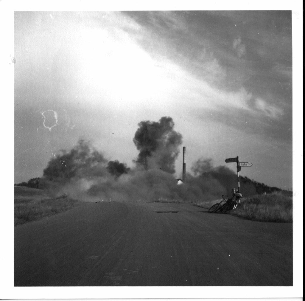
Image 5.2 – The large concrete barriers on the road bridge over Ryå are packed with explosives and blown up. There were roadblocks both on the west side of the road bridge and again at the western entrance to Aabybro. Many German facilities still stand today because they were simply too resource-intensive to remove. Over the smoke cloud, you can see the dairy’s chimney.
Photo: Historical Association for Aaby Parish.
Image 5.3 – The roadblock west of Aabybro was also blown up.
Photo: Historical Association for Aaby Parish.
Regelbau 621

Bunkers as Standard Houses
German bunkers were built according to the Regelbau system – a type of standardized housing system for bunkers. This allowed for faster and cheaper construction. The site manager at a given location could choose the bunker type that suited the task and area.
Six Bunkers in Stützpunkt Aabybro
The bunker you are standing on is of the Regelbau 621 type, the same as the five other bunkers that were part of Stützpunkt Aabybro and one of the most widespread bunker types in Denmark. The two entrances at the northern end lead to a gas lock and then to the living quarters. It was manned by 10 men. There were 9 bunk beds and one single bed, a table, and an iron stove for heating. The single bed was for the non-commissioned officer, who was the person in charge of the bunker. To the right of the entrances is a staircase to the observation post, where there was room for a machine gun.
Two Meters of Concrete
The walls and ceiling are two meters thick, and the bunker is buried 1.5-2 meters underground. The other bunkers in the support point, around Brogårdsvej to the north, are all located above ground due to the high groundwater level. This particular bunker was covered with soil when the sewage treatment plant was established in 1973. In 2024, after more than 50 years, it was unearthed again.
Image 1.1 – Blueprint of the Regelbau 621 bunker type. There are precise descriptions of how much earth needs to be moved, how much concrete is needed, and how much explosive force it can withstand, among other things. Type 621 was one of the most common bunkers in Denmark.
Image 1.2 – The antenna tube was used for radio communication. Normally, the antennas would be protected by two domes. This suggests that this bunker was not completely finished, as the two tubes stand unprotected.
Source: Jens Andersen, Bunkermuseum Hanstholm.
Image 1.3 – There is a hole for a periscope, which could be used to look out from the crew room. Originally, there was a cover to close the two holes when the periscope was not in use.
Source: Jens Andersen, Bunkermuseum Hanstholm.
Image 1.4 – The living room was heated by a stove, as the bunker would otherwise have been unbearably cold to stay in. The chimney is located on the west side of the roof.
Source: Jens Andersen, Bunkermuseum Hanstholm.